Professor

THE RESEARCH


Situated in a remote region of the eastern South Pacific, the Marquesas Islands are a group of twelve rugged volcanic islands that collectively make up the most northwestern archipelago of French Polynesia.  The Marquesas Islands collectively cover only 1050 km2 (Florence & Lorence 1997).  The twelve islands range in age from 1.3 million years (Fatu Hiva) to over 6 million years (Eiao); the oldest islands are located in the northwest and they become progressively younger towards the southeast (Florence & Lorence, 1997).  The Marquesas Islands are characterized by few beaches and extremely jagged terrain; steep vertical sea cliffs and deep isolated valleys separated by sharp imposing ridges are common throughout.  The largest and highest islands in the Marquesas are Nuku Hiva (elevation 1227 m) and Hiva Oa (elevation 1276 m) (Florence & Lorence 1997).  The Marquesas lie at the southern end of a regional oceanic low precipitation zone which is bordered by two rainy zones that converge to the west (Decker, 1970).  The windward (northeastern and southeastern) sides of the islands receive the most precipitation, and the leeward (western) sides tend to stay dry. These dry regions where once home to the endangered tropical dry forest.  These lower elevation sites have mean monthly temperatures ranging from 25°C to 29°C, receive less then 2000 mm of annual precipitation and have a dry season of 6 months (Florence & Lorence 1997).

Polynesians arrived to the Marquesas around 1700 years ago (Buck, 1953; Florence & Lorence, 1997).Map of Saipan Prior to European contact, the Marquesan population flourished with an estimated 80,000 inhabitants at its peak (Buck, 1953).  Spanish sailors visited the Marquesas Islands in 1595 under the direction of Avaro de Medaña and named the islands “Las Islas de Marquesa de Mendoza” in honor of the Viceroy of Peru (Florence & Lorence, 1997).  Contact with Western explorers brought disease and the native Marquesan population sunk to a mere 3800 inhabitants in 1938.  Nevertheless, by 1988 Marquesan numbers had managed to steadily increase to 7358 (Florence, 1993).

Dry forests of the Marquesas Islands occur in areas that experience less than 2000 mm of precipitation annually and range from just above sea level to 500 m in elevation (Florence & Lorence, 1997).  Many of the areas have been highly disturbed or have been converted into secondary vegetation, although fragments containing intact native species do exist (Florence & Lorence, 1997).  Many studies have maintained that much of the lowland native vegetation on the Marquesas Islands has been destroyed as a result of grazing and human impact (Decker, 1970; Florence 1997; Mueller-Dombois 1998).  This assessment is correct yet small fragments of native dry forest were encountered during this study.

Study Sites:
(Refer to map above for Study Site links.)
Six study sites were surveyed on the two largest islands of Nuku Hiva (Hatiheu Bay, Hakaui, Terre Déserte) and Hiva Oa (Nahoe, Hanaiapa Bay, Eiaone).


MAPS

IMAGESThumb 1

VIDEO

DATA


title NUKU HIVA ISLAND title

Location: HATIHEU BAY

The first surveyed site was located on the west side of Hatiheu Bay, north of the village of Hatiheu, on an east-facing slope on the Northwestern coast of Nuku Hiva.  The Hatiheu Bay dry forest fragment was located in a gully with large volcanic rock outcrops that protect it from fire.  The area did not appear to be disturbed by humans and many native species were observed, however, there was significant evidence of grazing by feral goats.  The forest had a low density of tree species and was dominated by Sapindus saponaria and Xylosma suaveolens.


dft
title NUKU HIVA ISLAND title
Hakaui

Location: HAKAUI

The second site was located just north of the village of Hakaui, Nuku Hiva on a north-facing slope with many volcanic boulders.  The site appeared to be minimally disturbed judging by the presence of many indigenous species and by its isolated location.  This forest contained the highest species richness of native trees in the Marquesas Islands and was dominated by Glochidion marchionicum, Sapindus saponaria, Xylosma suaveolen, and Cerbera manghas.  However, there was a high number of non-native species, especially Tecoma stans, encountered in the transects.

Hakaui
title NUKU HIVA ISLAND title

Location: Terre Déserte

The Terre Déserte study site faced north in the dry northwestern section of Nuku Hiva, just southeast of the Nuku Ataha Airport.  This was the most disturbed of all six sites with extensive evidence of goats and fire in the area.  This fragment was surrounded by grasslands and contained the lowest species richness with only three native species. 


Terre Désert
Terre Désert
title HIVA OA ISLAND title

Location: NAHOE

The fourth dry forest site was on a north-facing slope on the northeastern coast of Hiva Oa just southeast of the village of Nahoe.  This site contained many volcanic boulders and smaller rocks.  The site itself contained many native species that are protected from fire by low leaf litter and a gully.  


Nahoe Site
Nahoe Site
title HIVA OA ISLAND title

Location: HANAIAPA BAY

The fifth surveyed site on an east-facing slope on the west side of Hanaiapa Bay along the north-central coast of Hiva Oa.  This site contained large volcanic outcrops in addition to smaller rocks.  Feral goats were seen at lower elevations below the site, but the dry forest fragment appeared intact and exhibited many native species. 


Hanaipa Bay Site
Hanaiapa Bay
title HIVA OA ISLAND title
Eiaone

Location: EIAONE

The final site was found on the west side of a small unnamed bay on a Northeast-facing slope along the Northeastern coast of Hiva Oa.  The Eiaone site had large volcanic boulders.  The forest contained the highest species richness of native trees on the island of Hiva Oa.  This is the only site where the gigantic Pisonia grandis was observed. 


EiaoneEiaone
title CONSERVATION SUGGESTIONS title

Locals

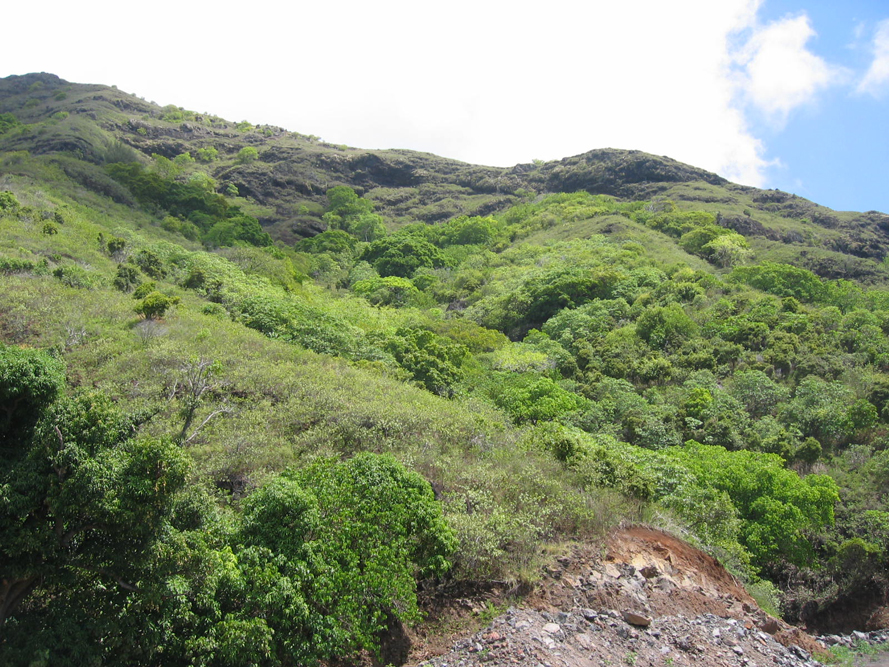
Extensive and systematic plants inventories are need of the lowland areas on the Marquesas Islands.  Currently, there are only species lists for the islands and more research needs to be undertaken to identify rare species (Wagner & Lorence 2003).  Fenced enclosures with public assess for locals and tourists are needed at the richest sites.  There also needs to be a public education campaign on the conservation of this forest type. 

title REFERENCES title

Buck, P. H. (Te Rangi Hiroa). 1953. Explorers of the Pacific. Bernice P. Bishop Museum special publication 43. Honolulu.

Decker, B.G. “Plants, man, and landscape in Marquesan valleys, French Polynesia.” Ph.D. dissertation, University of California, Berkeley, 1970.

Decker, B.G. 1992. Secondary plant cover on upland slopes, Marquesas Islands, French Polynesia. Atoll Research Bulletin 363:1-36.

Florence, J. 1993. La Végétation de quelques îles de Polynésie française. Planches 54–55. In: J.-F. Dupon et al., Atlas de la Polynésie française.  Editions de l'ORSTOM, Paris.

Florence, J., and Lorence, D.H. 1997. Introduction to the flora and vegetation of the Marquesas Islands. Allertonia 7(4): 226-237.

Mueller-Dombois, D., and Fosberg, F.R. 1998. Vegetation of the tropical Pacific islands. Springer-Verlag, New York.

Wagner, Warren L. and Lorence, David H. 2003. Flora of the Marquesas. Smithsonian Institution and National Tropical Botanical Garden. Accessed 27 October 2006.  <http://ravenel.si.edu/botany/pacificislandbiodiversity/marquesasflora/index.htm>.

Acknowledgments

I would like to thank Travis Terpkosh for undertaking his Master’s thesis research in the Marquesas.  Tikal and her mother were extremely kind and helpful.  We are also very grateful to the tour guides and cab drivers on the islands.

Image: Travis Terpkosh

Thank you to Google Earth for providing the plot images.

Return to Top of Page