Urban Heat Island &
Cooling Effect of Trees
Download Printable Version Soon
RESEARCH SUMMARY
Dr. Sassan Saatchi

Urban heat island (UHI) refers to the characteristic warming of urban areas compared to their rural surroundings as a result of changes of surface and atmospheric conditions from urbanization (expansion of buildings, roads, pollution, energy use, etc.).  UHI is an inadvertent climate change that arises from changes to surface radiation and energy balance and reduction of cooling rates in urban areas. The effect is attributed to the large expansion of non-evaporative impervious material covering large urban areas with consequence of an increase in sensible heat flux and decrease in latent heat flux ((Voogt & Oke, 2003).   UHI has significant implications for human comfort and health, urban air pollution, energy management, and urban planning.  In cities located in hot climates, UHI causes higher cooling loads and energy use with increased human discomfort.  In temperate and cold climates, heat island may provide some benefits especially in winter by reducing heating load.

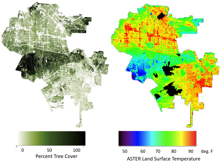
In Los Angeles, the semi-arid landscape, warm climate, and topographically complex terrain, the urban heat island can be a major concern for urban planning and water and energy use management.  Over-population, urban sprawl, concentrated pollutions, and anthropogenic heat generated by traffic, industry, and domestic buildings are other effects exacerbating the UHI in Los Angeles (Figure 1). 

To mitigate these effects requires large scale urban planning, development of environmentally sound infrastructure, and major adjustments to social and economic policies. 

Urban shade trees offer significant benefits in reducing the demand for cooling and energy use and improving the air quality and pollution over the city. The Los Angeles Million Tree initiative provides a great opportunity to increase the tree cover and to reduce the UHI effects.  However, the implementation of the initiative requires detailed understanding of the effect of trees in cooling the surface temperature, their spatial distribution along industrial and major transportation corridors, and across the urban landscape.

To address this, our research uses a combination of satellite derived tree cover (McPherson, 2003), vegetation index, and surface temperature to quantify: 1. The relative impact of trees on reducing UHI.  2. The relative impact of climate change and variability on UHI. 3.The changes of surface temperature as a result of urbanization and tree cover over the past 30 years.  The result of this study are readily integrated with other research activities within our group to estimating the social and economic benefits, to examine the water and carbon sequestration of urban trees, to compare with the historic reconstruction of tree cover, and the institutional and logistic implementation of Million Tree initiative.

RESEARCH METHODOLOGY AND RESULTS

We compiled satellite visible and thermal data from Landsat series and ASTER imagery over Los Angeles for the past 30 years.   Data from thermal bands were collected for both day and night times and different dates, capturing both diurnal and seasonal variations of distribution of heat over the city.  All satellite thermal bands were calibrated to represent land surface temperature (LST) using data  from16 meteorological stations distributed over the city.  By using tree cover data produced by McPherson (2003), we developed a multivariate analysis to quantify the impact of tree cover of tree cover on UHI effects.  The results are summarized as follows:


Figure 1. Distribution of tree cover and land surface temperature (LST) over Los Angeles County.  Areas of low tree cover and larger impervious surface correspond to areas of higher LST. Tree cover data is derived from pixel aggregation of high resolution McPherson (2003) tree cover data and LST imagery from ASTER thermal bands calibrated with temperature data from 16 meteorological stations.

 
Figure 2. Relative impact of shaded trees and irrigated grass on reducing land surface temperature and mitigating Los Angeles urban heat island.

FUTURE WORK
 
Our study with UHI will follow to include the long-term historical changes on tree cover and its impact on LST, the spatial distribution of UHI across the city with different infrastructure, socio-economic characteristics, and water and energy use, and comparison of Los Angeles UHI with other cities in California and southwestern U.S.  Check back here for updates or email ssaatchi@ucla.edu, saatchi@jpl.nasa.gov if you have questions or need more information.


Collaborators:
Dr. Trevon Fuller (Postdoc), Katherine Mertes (Research Assistance)
Katherine Radke (UCLA Student 2007-2008)